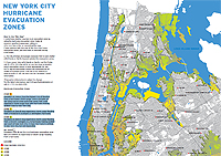
NEW
YORK CITY HURRICANE EVACUATION ZONE MAP - 2012
Residents
in Zone A face the highest risk of flooding from a hurricane's
storm surge. Zone A includes all low-lying coastal areas and other
areas that could experience storm surge from ANY hurricane making
landfall close to New York City.
Residents
in Zone B may experience storm surge flooding from a MODERATE
(Category 2 and higher) hurricane.
In
2011, New York City "Zone A" residents faced
mandatory evacuation. Major affected neighborhoods included:
Manhattan’s Battery Park City, Coney Island and other Brooklyn
beach communities, The Rockaways in Queens, Shore areas of Staten
Island. The NYPD enforced the evacuation mandate.

CLICK
HERE TO OPEN THE HIGH-RES PDF MAP


